
Lake St Clair – Fishing Canada Bass 101
One thing is for sure, the Canadian side of Lake St. Clair endures only a fraction of the fishing pressure that the U.S. side does. That fact alone makes it an attractive option when planning a bass fishing trip on Lake St. Clair.
In addition, the delta system that is Lake St. Clair creates many unique opportunities throughout the water on the Canadian side. The sheer size of the area involved can make it hard to decide where to fish. This article may bring some clarity, by drawing a big picture that identifies bass fishing zones.
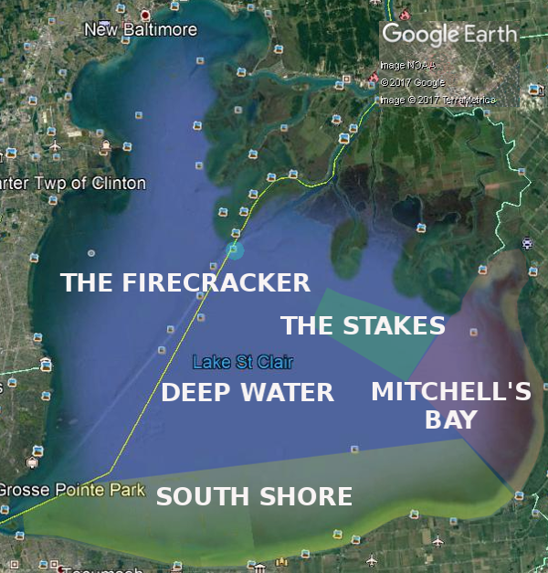
South Shore (Sand/rock combinations, rock/sand, rock cabbage)
This zone is likely responsible for the majority of bass caught on the Canadian side. The reason for that is the heavy presence of smallmouth available in 12 feet of water or less. The long sandy break has miles of scattered rock piles that are both near, and away from shore.
Mitchell’s Bay (Sand/weed combinations, large weedbeds, shallow and deep weedbeds)
Historically, the water in this zone has been crystal clear to as much as 18 feet. Recently, the water clarity had gone through a few years where it didn’t clear up much for summer. By satellite, this year looks like things are back to normal.
Known as a bass factory, many tournaments of the past have been won out of this zone.
The Bay itself is not very deep, has some smallmouth available, but is notorious for backwater largemouth. The tournament quality bass tend to come from outside of the bay, in deeper water. The local expression that, “I caught my fish in Mitchell’s Bay” normally means that the bass were caught while in sight of Mitchell’s Bay landmarks.
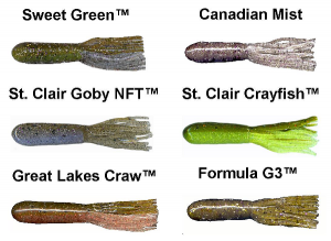
These Xtreme Bass Tackle tube colors are designed for Lake St. Clair smallmouth fishing
The Stakes (Sand, sand weed, sandy drop-off, weed patches, weed lines)
This zone is known for the Walpole Island First Nation territory line that may be seen on the water with wooden “stakes” driven into the sand. “Back in the day” this stake line was well maintained, but in recent years there are far fewer markers that can be seen. Modern GPS systems may display the boundary on the chart. Old school paper maps (NOAA included) clearly show the length, and direction of this boundary.
This is a classic Delta system outflow from the St. Clair River. The water is usually crystal clear unless there is a storm event that suspends the bottom silt for a short time.

Capt. Wayne Carpenter’s, No Secrets on Lake St. Clair Vol. 4 at Xtreme Bass Tackle and local stores on Lake St. Clair
The Firecracker (Fixed channel marker, flats, cabbage, current)
This spot is popular because is the gatekeeper between the Lake, and the St. Clair River shipping channel. It is a perennial hot spot but fishing pressure comes and goes based on fishing reports based on rumors, or reputation.
The marker, and the area surrounding it present many opportunities for an experienced smallmouth angler to take advantage of.
Deep Water (Deepest St. Clair water, tall cabbage beds, isolated structure)
This is the deepest water in the Lake, with the exception of the dredged shipping channel. It has been discovered to hold some of the biggest schools, of the biggest smallmouth around. The trick is finding them in the vast expanse.
The trip from the U.S. side to the Canadian side is worth it. Aside from the quality fishing, upon returning to the U.S., you will instantly appreciate the calm waters that you have been fishing in all day.
Category: Bass Fishing Articles, Feature


