
St Clair River Upper Depth Change US Corps Tracking Data
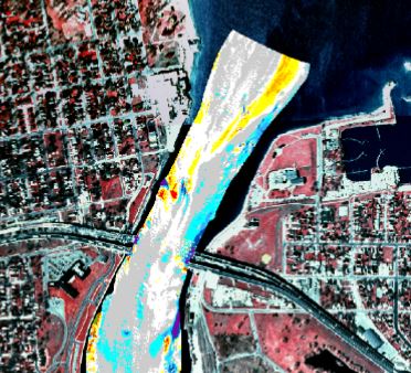
Part of the graphic representation of what the Corps of Engineers put in their report
The US Army Corps of Engineers tracks and controls many aspects of navigable waters as is shown in this depth change report for the upper two miles of the St. Clair River. Although this report is dated as 2006, it can still be useful to view areas that are likely to fluctuate and those that don’t change at all.
This zone is at or near some of the hottest competitive bass fishing spots in the last decade. If you are looking to make the long run up, it helps to understand how the river is constantly changing.
We look to the Corps for solid data on the Great Lakes system. This report is another example of how they can help us get the most out of this fishery.
Click and see the full report here
Category: Feature, Water Levels


